
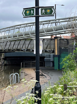
 London’s newest walking route, the Green Link Walk, is now open. It connects nearly 40 areas of green space large and small. Our news page for the route has a map giving an overview of the whole walk which runs from Epping Forest to Peckham.
Most of the route has now been waymarked but there are some gaps both in the Lea Valley and in the City of London. Work continues to improve the signage along the route.
The main route has been designed with accessibility in mind. As well as removing barriers such as bollards to ensure that everyone can access the route, the Green Link Walk also avoids streets without dropped kerbs and bridges with steep ramps and steps.
Our walk guidance offers alternative routes and diversions that explore more of the green spaces and places of interest along the way. These variants, however, may not meet the wheelability standards of the main route.
Download your free walk guidance here
Click on the title of a section, in the table below, to download the PDF file of walk guidance with maps.
We have walked the route several times to check that our guidance is as clear as possible.
Green Link Walk news page
Ramblers volunteers monitor all sections of the Green Link Walk with the aim of ensuring that they are properly maintained and improved for the public to enjoy. We report any short term changes that make it difficult to walk any of the sections on the news page for the Green Link Walk.
Give us your feedback - please
Please
| Section | Distance | Transport to start | Transport from end |
| Epping Forest to Lea Bridge | 4.5 miles | 20 bus to Woodford New Road | 55 or 56 bus from the Lee Valley Ice Centre |
| Lea Bridge to Regent’s Canal | 5.0 miles | 55 or 56 bus to the Lee Valley Ice Centre | Angel tube station |
| Regent’s Canal to Bankside | 2.5 miles | Angel tube station | Blackfriars station |
| Bankside to Peckham | 4.0 miles | Blackfriars station | Peckham Rye station |